mongabay.com
June 09, 2009
Satellite images released by NASA show nearly complete destruction of Rwanda's Gishwati Forest between 1986 and 2001. Deforestation of the forest reserve is largely the result of subsistence harvesting and cultivation by refugees in the aftermath of the country's 1994 genocide. Overall only 600 hectares of Gishwati's original 100,000 hectares of forest remain, a loss of 99.4 percent.
"According to UNEP, the reserve's forests were largely intact in 1978, and substantial forest cover still remained in 1986. But in the 15 years that elapsed between these images�a time that spanned the country�s tragic genocide�wave after wave of refugees arrived in Gishwati Forest and began clearing it, often for subsistence farming," wrote Michon Scott and Rebecca Lindsey on NASA's Earth Observatory site. "By 2001, only a small circular patch of native forest remained�1,500 acres of the forest�s original 250,000."
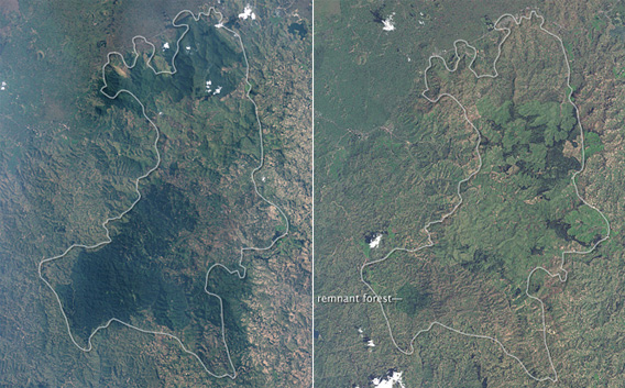
NASA�s Landsat 5 satellite captured the left-side image on July 19, 1986, while NASA�s Landsat 7 satellite captured the right-side image on December 11, 2001. Densely forested areas are deep green.
Large tea estates and plantations now occupy the park, which is located in the northwestern part of the country.
more:
http://news.mongabay.com/2009/0609-nasa_rwanda.html