 http://www.geni.org/globalenergy/library/buckminster_fuller/dymaxion_map/dymaxion_projection.shtml
A New Perception of Earth
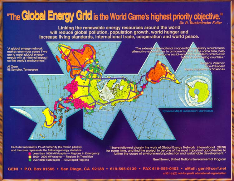
World maps are symbolic tools which help to shape our perception of Earth. Every world map projection must make certain compromises as information is transferred from a spherical globe to a flat surface. With this in mind, as early as 1927 Buckminster Fuller, an educator, engineer, architect, author, cartographer and futurist, set out to develop the world's most accurate 2-dimensional world map.
He wanted to provide a view of the whole Earth at once which would have the ability to reveal major trends in world affairs and show the shortest air routes between land masses. Fuller predicted even then that global travel would shift from the sea to the sky and anticipated the emergence of what he termed 'a OneTown Air-Ocean World.'
Designing for Accuracy
Using the some mathematical principles on which his world famous geodesic domes were to be based, Fuller carefully designed a way to display the world all at once, with the least amount of visual distortion. Throughout the next 26 years he refined his world projection through many successive versions in order to reach the highest level of accuracy.
In 1954 Fuller called his final icosahedral projection the 'Dymaxion Air-Ocean World.' (The term 'Dymaxion' was coined in the 1930's from Fuller's most commonly used words: dynamic, maximum and tension.)
In 1980, an even more elegant and accurate Dymaxion Map was developed by Fuller associates Rob Grip and Christopher Kitrick, by using computer-generated algorithms for latitude and longitude information. Now a brand new edition of Fuller's remarkable map, 'The Fuller Projection' has been designed and updated by the Buckminster Fuller Institute using the distinguished cartographic services of R.R. Donnelley & Sons.