Environment & Energy
Related: About this forumTwo-Mile-Long Melt Lake Forms In 1 Day - But In East Antarctica Rather Than Greenland
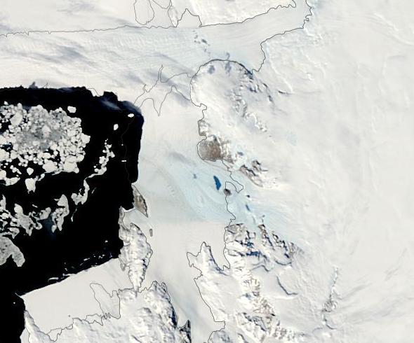
It’s right there in the satellite image. A swatch of blue that seems to indicate an approximate 2-mile long melt lake formed over the surface of East Antarctica in just one day. If confirmed, this event would be both odd and concerning. A part of the rising signal that melt stresses for the largest mass of land ice on the planet are rapidly increasing.
 ?w=600
(Possible large melt lake on the surface of an ice shelf along the Scott Coast appears in this NASA satellite image. The melt lake seems to have formed after just one day during which föhn winds ran downslope from the Transantarctic Mountain Range — providing a potential period of rapid heating of the glacier surface.)
EDIT
East Antarctica, according to Stewart Jamieson, a glaciologist at Durham University in the U.K., is “the part of the continent where people have for quite a long time assumed that it’s relatively stable, there’s not a huge amount of change, it’s very, very cold, and so, it’s only very recently that the first supraglacial lakes, on top of the ice, were identified.” But now, even in austral springtime, we find evidence of surface melt in the satellite record.
On November 27, 2016, what looks like an approximate 2 mile long melt pond appeared in a section of ice shelf along the Scott Coast and just North of the Drygalski Ice Tongue in the region of McMurdo Sound. The lake — which is visible as a light blue swatch at center mass in the NASA-MODIS satellite image above — suddenly showed up in November 27 satellite image along a region where only white ice was visible before. And it appears in a region of East Antarctica that, before human-forced warming altered the typically-stable Antarctic climate, had rarely, if ever, seen surface melt.
 ?w=600&h=348
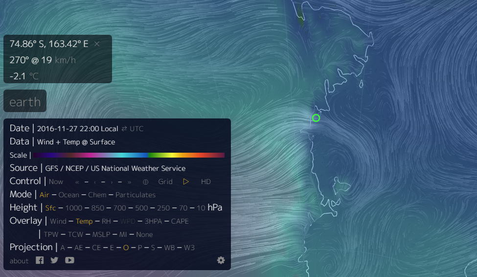
(Near melting point temperatures appear along the Scott Coast in conjunction with an apparent föhn wind event. Image source: Earth Nullschool.)
The pond shows up coordinate with recorded near 0 C surface temperatures in the GFS monitor for November 26-27 and along with evidence of downsloping (föhn) winds. GFS indicators show downsloping winds gusting to in excess of 50 mph over the period. Such winds have the potential in increase surface temperatures by as much as 14 degrees Celsius in a matter of minutes. And they have, increasingly, produced surface glacial melt events in regions of Greenland and Antarctica during recent years.
EDIT
https://robertscribbler.com/2016/11/28/did-fohn-winds-just-melt-two-miles-of-east-antarctic-surface-ice-in-one-day/
 = new reply since forum marked as read
Highlight:
NoneDon't highlight anything
5 newestHighlight 5 most recent replies
= new reply since forum marked as read
Highlight:
NoneDon't highlight anything
5 newestHighlight 5 most recent replies

byronius
(7,414 posts)I know this must be difficult for you; nothing but disastrous news. But it's still important.
Everyone's speculating on what 'crisis' the GOP will use to declare martial law. But this crisis dwarfs anything else in the quiver.

Boomer
(4,170 posts)I've been reading Hatrack's DU posts for years. Thank you!

progressoid
(50,030 posts)I need a drink.