Democratic Underground Latest Greatest Lobby Journals Search Options Help Login
Google

BREAKING - Tropical Storm Fay: All yachts over 500 tons could be required to leave Port Key West

Printer-friendly format Printer-friendly format
Printer-friendly format Email this thread to a friend
Printer-friendly format Bookmark this thread
This topic is archived.
Home » Discuss » Latest Breaking News Donate to DU
 
Mika Donating Member (1000+ posts) Send PM | Profile | Ignore Sun Aug-17-08 01:57 PM
Original message
BREAKING - Tropical Storm Fay: All yachts over 500 tons could be required to leave Port Key West
Source: BYM

Effective 12:00 p.m. Sunday, Hurricane Condition YANKEE (sustained Gale Force winds from a hurricane force storm are predicted within 24 hours) is set for the Port of Key West, Fla. All mariners are reminded that there are no safe havens for the Port of Key West area and that the port is safest when the inventory of vessels is at a minimum. For planning purposes, all oceangoing vessel and barges over 500 gross tons will be required to depart Port of Key West and head out to sea when Hurricane Condition YANKEE is set. Inland vessels and barges over 500 gross tons are required to seek safe refuge in a port outside the Port of Key West.
Vessel movement will be restricted and allowed only on a case-by-case basis by approval of the Captain of the Port. All vessels expecting to conduct cargo operations during Condition YANKEE shall submit a Cargo Operations Plan to terminal owners for approval. All ship-to-shore operations must be completed six hours prior to the setting of Port Condition ZULU.
Affected ports are closed to inbound traffic.
Anticipate drawbridges may be closed to vessel traffic as early as eight hours prior to the arrival of tropical storm force winds.
Coast Guard Port Survey teams will conduct Port Condition YANKEE validation.
Tropical Storm Fay is expected to develop into a hurricane. All marine interests must take early and substantial action to ensure safety of the port and vessels. Future port conditions cannot be predicted with any degree of certainty, but provided the storm remains on the projected course and track, port stakeholders can expect the following progression of port conditions.
Sustained gale force winds from a hurricane force storm are predicted within 24 hours.


Read more: http://www.bymnews.com/news/newsDetails.php?id=41134


It really hurts to have to move one's 500+ ton yacht.
Printer Friendly | Permalink |  | Top
Faygo Kid Donating Member (1000+ posts) Send PM | Profile | Ignore Sun Aug-17-08 02:01 PM
Response to Original message
1. Man, I gotta get down there and get mine to safety.
She's a nice little thing. Good fer bass fishin'


Printer Friendly | Permalink |  | Top
 
Mika Donating Member (1000+ posts) Send PM | Profile | Ignore Sun Aug-17-08 02:04 PM
Response to Reply #1
3. A tax cut put to use.
Edited on Sun Aug-17-08 02:05 PM by Mika
Who needs national infrastructure with a comfy little boat like that?

http://www.youtube.com/watch?v=mn4daYJzyls

:tv:


Printer Friendly | Permalink |  | Top
 
Faygo Kid Donating Member (1000+ posts) Send PM | Profile | Ignore Sun Aug-17-08 02:28 PM
Response to Reply #3
7. Ain't it the truth.
Off with their heads.

Check this site out. No shortage of money out there. I guess the new Russian billionaires are driving prices up, too. I read that a French Riviera mansion just went for $750 million - a new record for a "home."

Anyway, don't be gaudy - don't buy more than two of these:
http://www.cnconnect.com/sales/yachts.aspx
Printer Friendly | Permalink |  | Top
 
jhrobbins Donating Member (1000+ posts) Send PM | Profile | Ignore Sun Aug-17-08 03:31 PM
Response to Reply #7
11. I read that too, but that sale was a quantum leap for real estate -
even expensive real estate. For a while the most expensive homes anywhere, London, Aspen and Dubai were around the 125 mil mark. This sale is an obscenity!!
Printer Friendly | Permalink |  | Top
 
wordpix Donating Member (1000+ posts) Send PM | Profile | Ignore Sun Aug-17-08 11:50 PM
Response to Reply #7
37. keep polluting that ocean with your ocean liners - grr
Printer Friendly | Permalink |  | Top
 
Faygo Kid Donating Member (1000+ posts) Send PM | Profile | Ignore Mon Aug-18-08 05:20 PM
Response to Reply #37
41. It's OK. Here's how I power it.
The added bonus is I get a good workout rowing that sucker.

Printer Friendly | Permalink |  | Top
 
Xipe Totec Donating Member (1000+ posts) Send PM | Profile | Ignore Sun Aug-17-08 02:33 PM
Response to Reply #1
8. You're in luck; There's still room in my private docks


Make yourself at home, the key is under the welcome matt.
Printer Friendly | Permalink |  | Top
 
Faygo Kid Donating Member (1000+ posts) Send PM | Profile | Ignore Sun Aug-17-08 02:45 PM
Response to Reply #8
9. Thanks. But you have to promise to visit me, too.
Just tell the butler that Bubba sent you. There's some cold Pabst in the fridge, and plenty of Doritos always on hand.

Printer Friendly | Permalink |  | Top
 
cobalt1999 Donating Member (1000+ posts) Send PM | Profile | Ignore Sun Aug-17-08 06:02 PM
Response to Reply #1
19. Unless you own a Wally Gigayacht
It is it's own island

325 ft / 2,730 tons


Printer Friendly | Permalink |  | Top
 
not fooled Donating Member (553 posts) Send PM | Profile | Ignore Sun Aug-17-08 11:28 PM
Response to Reply #19
36. You people...
...crack me up

:rofl: :rofl: :rofl: :rofl: :rofl:

oh wait,those are your and my tax dollars, wages, raises, pensions, etc. etc. etc. after being funneled up. Never mind.:cry:
Printer Friendly | Permalink |  | Top
 
Mika Donating Member (1000+ posts) Send PM | Profile | Ignore Sun Aug-17-08 02:01 PM
Response to Original message
2. U.S. Coast Guard warns South Florida boaters
U.S. Coast Guard warns South Florida boaters
http://www.sun-sentinel.com/news/weather/hurricane/sfl-boat081708,0,7482823.story
Boaters need to remove, secure or reroute vessels in South Florida waters as Tropical Storm Fay barrels toward the area, the U.S. Coast Guard said this afternoon.

Effective at noon today, vessel movement in the Port of Key West is being restricted because of the gale force winds predicted within 24 hours, a condition dubbed "Hurricane Condition YANKEE," Coast Guard spokeswoman Petty Officer Jennifer Johnson said. As part of preperations, vessels are being allowed to move within the area on a case-by-case, emergency basis.

"All mariners are reminded that there are no safe havens for the Port of Key West area and that the port is safest when the inventory of vessels is at a minimum," Johnson said in a news release.

"For planning purposes, all oceangoing vessel and barges over 500 gross tons will be required to depart Port of Key West and head out to sea when Hurricane Condition YANKEE is set," Johnson said. "Inland vessels and barges over 500 gross tons are required to seek safe refuge in a port outside the Port of Key West. Inland vessels and barges over 500 gross tons are required to seek safe refuge in a port outside the Port of Key West."

Ports in Miami, Tampa-St. Petersburg, and Manatee County are on a 48-hour alert storm preparation mode less restrictive than in the Keys for now, she said. Mariners using east coast ports from Broward north to St. Lucie counties should also be taking precautions.

"Recreational vessels should take the proper precautions now, in case the tropical storm hits," Johnson said, adding that they should be removed from the water or tied down.

"All marine interests must take early and substantial action to ensure safety of the port and vessels," Johnson said.

For more information, call Coast Guard Sector Key West at 305-295-9700.


Printer Friendly | Permalink |  | Top
 
saltpoint Donating Member (1000+ posts) Send PM | Profile | Ignore Sun Aug-17-08 02:04 PM
Response to Original message
4. Just spoke within the hour with friends in Sarasota County. They say
a lot of folks in the state are aware of Fay's approach but don't think there's as much to it as Charlie Crist seemed to suggest.

They figure is isn't going to be much like Hurricane Charlie, let alone much like Andrew.

They're doing the flashlight batteries, DVD rentals, and booze thing, but not very many people of their acquaintence are evacuating.

Things change with tropical storms, but for now it looks like no one's in panic mode.
Printer Friendly | Permalink |  | Top
 
Mika Donating Member (1000+ posts) Send PM | Profile | Ignore Sun Aug-17-08 02:11 PM
Response to Reply #4
5. But I remember Wilma a couple of years ago.
Edited on Sun Aug-17-08 02:11 PM by Mika
It was supposed to be a Cat 1. But then it kicked up just as it made landfall and really made a mess. I've been through many hurricanes here in S Florida, including Andrew, and Wilma was very strange and intense for a Cat 1.

:hi:


Printer Friendly | Permalink |  | Top
 
saltpoint Donating Member (1000+ posts) Send PM | Profile | Ignore Sun Aug-17-08 02:13 PM
Response to Reply #5
6. True enough.
"Now it's a thing that us old-timers know
In a sultry summer calm
there comes a blow from nowhere
And it goes off like a bomb..."

--Stan Rogers


--borrowing there from the late Stan Rogers, who sang of other storms in other bodies of water, but the effect is similar.

Agree -- the storms decide where they go and how deep a mark they leave.

Printer Friendly | Permalink |  | Top
 
MBS Donating Member (1000+ posts) Send PM | Profile | Ignore Sun Aug-17-08 04:16 PM
Response to Reply #6
14. ah, Stan Rogers -- YES!
I knew you were a good guy. :D
Printer Friendly | Permalink |  | Top
 
saltpoint Donating Member (1000+ posts) Send PM | Profile | Ignore Sun Aug-17-08 06:47 PM
Response to Reply #14
22. It is a real lift to run into someone who likes Stan Rogers.
Bless you with unending and always-cold ale from the best tap there is.

Nothing against the kids but Stan was by far the greatest Mr. Rogers.

"Ah for just one time / I would take the Northwest Passage..."
Printer Friendly | Permalink |  | Top
 
geomon666 Donating Member (1000+ posts) Send PM | Profile | Ignore Sun Aug-17-08 03:15 PM
Response to Reply #5
10. Wilma was a CAT 5 at one point.
I don't who thought it was going to land as a CAT 1 but they weren't thinking properly. It nearly destroyed Cancun before it swung over to Florida and decimated our electrical grid.
Printer Friendly | Permalink |  | Top
 
Dr.Phool Donating Member (1000+ posts) Send PM | Profile | Ignore Sun Aug-17-08 04:13 PM
Response to Reply #4
13. They just extended the hurricane watch north to Tarpon Springs.
So, I guess I'm safe. If I walk across the street, dive into the Anclote River and swim 50 yards, I'll be in Tarpon Springs.

This one is starting to look a lot like Charlie to me. Cat 1 in the Florida Straits, and it was forecast to come right up my driveway, until about 5 hours earlier, it decided to go Cat 4 and hit Port Charlotte instead.
Printer Friendly | Permalink |  | Top
 
flvegan Donating Member (1000+ posts) Send PM | Profile | Ignore Sun Aug-17-08 05:25 PM
Response to Reply #13
16. Exactly what I was thinking.
Just watched the NBC VIPR prediction, and it thinks it's going a bit east, hitting Sarasota as a cat 1 and going NW through the state.
Printer Friendly | Permalink |  | Top
 
csziggy Donating Member (1000+ posts) Send PM | Profile | Ignore Sun Aug-17-08 08:50 PM
Response to Reply #16
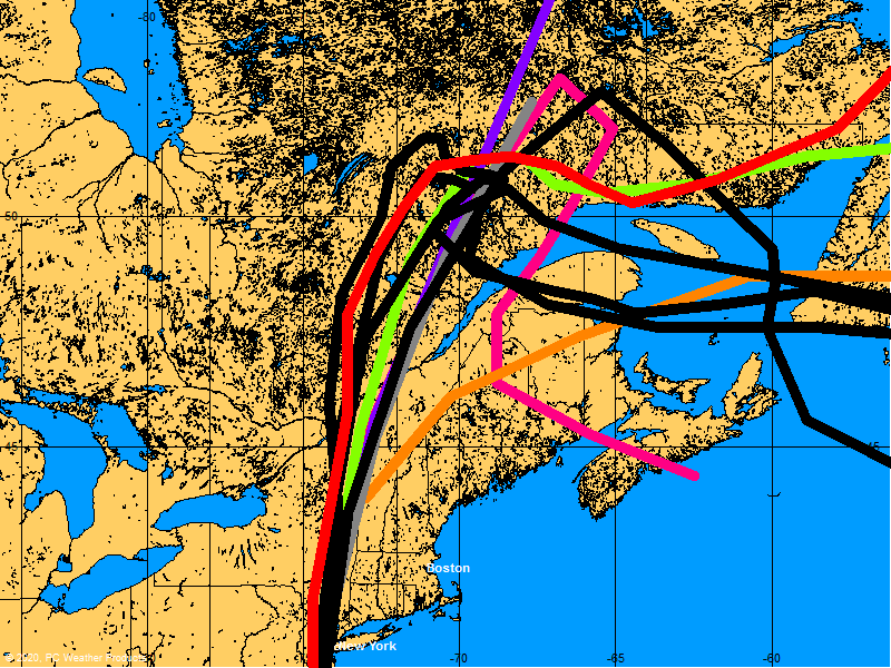
32. BoatUS shows the spaghetti models
http://www.boatus.com/hurricanes/tracking.asp

For the last two days, the evening projections show it hitting above Tarpon Springs; the morning ones show it hitting at Punta Gorda.


If it stays over the Gulf longer, it gets more powerful (duh!).

Either way, the west coast of Florida will have a problem.
Printer Friendly | Permalink |  | Top
 
wordpix Donating Member (1000+ posts) Send PM | Profile | Ignore Sun Aug-17-08 11:55 PM
Response to Reply #4
38. here's a suggestion for people in "low lying areas"-- all the keys, that is
snip:

Keys officials encouraged people who live in low-lying areas, in mobile homes and on boats to evacuate and said four shelters would open at 7 p.m. Sunday.
Printer Friendly | Permalink |  | Top
 
Captain Hilts Donating Member (1000+ posts) Send PM | Profile | Ignore Sun Aug-17-08 04:05 PM
Response to Original message
12. Small motor boats you pull out of the water, then fill with water so they won't blow around.
Edited on Sun Aug-17-08 04:05 PM by MookieWilson
And if the power goes out or whatever, you can use that water to flush toilets, etc.
Printer Friendly | Permalink |  | Top
 
Dr.Phool Donating Member (1000+ posts) Send PM | Profile | Ignore Sun Aug-17-08 04:16 PM
Response to Reply #12
15. I'm prepared.
I have the pool for flushing water, 15 cases of bottled for drinking and cooking, and enough canned tuna, and such to feed the Red Army for 10 minutes. And plenty of booze too.
Printer Friendly | Permalink |  | Top
 
TommyO Donating Member (1000+ posts) Send PM | Profile | Ignore Sun Aug-17-08 05:26 PM
Response to Reply #15
17. Emergency preparedness is no laughing matter
but somehow, I laughed at your post, especially feeding the Red Army for 10 minutes!
Printer Friendly | Permalink |  | Top
 
treestar Donating Member (1000+ posts) Send PM | Profile | Ignore Sun Aug-17-08 05:35 PM
Response to Original message
18. How awful!
:nopity: :nopity: :nopity: :nopity: :nopity: :nopity: :nopity: :nopity: :nopity: :nopity:

:nopity: :nopity: :nopity: :nopity: :nopity: :nopity: :nopity: :nopity: :nopity: :nopity:

:nopity: :nopity: :nopity: :nopity: :nopity: :nopity: :nopity: :nopity: :nopity: :nopity:

:nopity: :nopity: :nopity: :nopity: :nopity: :nopity: :nopity: :nopity: :nopity: :nopity:

:nopity: :nopity: :nopity: :nopity: :nopity: :nopity: :nopity: :nopity: :nopity: :nopity:
Printer Friendly | Permalink |  | Top
 
MGKrebs Donating Member (1000+ posts) Send PM | Profile | Ignore Sun Aug-17-08 06:32 PM
Response to Original message
20. That's gonna cost me $150,000 just to move it.
They are gouging us on diesel prices; I'll have to pay for berthing space somewhere; the crew must be paid. It just goes on and on.

Perhaps I'll turn this into a vacation. Haven't been to Malta in a while.

Printer Friendly | Permalink |  | Top
 
Mika Donating Member (1000+ posts) Send PM | Profile | Ignore Sun Aug-17-08 06:40 PM
Response to Reply #20
21. It is a trickle down jobs program.
A teak deck needs to be swabbed by someone!


Fuel consumption is measured in gallons per mile.


Printer Friendly | Permalink |  | Top
 
Mika Donating Member (1000+ posts) Send PM | Profile | Ignore Sun Aug-17-08 08:12 PM
Response to Original message
23. Tropical storm Fay moves on Cuba, Florida on alert
Source: AFP

HAVANA (AFP) — Tropical storm Fay bore down on Cuba Sunday after leaving five dead and one missing in the Dominican Republic and Haiti, as Florida declared an emergency and ordered tourists to leave the popular southern Keys.
The Miami-based US National Hurricane Center warned Sunday that Fay, already packing winds of up to 85 kilometers (50 miles) an hour, could evolve into a hurricane in the coming hours and dump several inches of rain over Cuba, Jamaica and the Cayman Islands before lashing Florida on Monday.
It forecast Fay could soon be packing hurricane-strength winds of 120 kilometers (75 miles) an hour, and placed a hurricane warning on parts of Cuba, islands off the southern tip of Florida and halfway up Florida's west coast.

-

Cuban authorities said Sunday that more than 10,000 people living in the path of the storm had been evacuated, as heavy wind and rain began battering the eastern coast.
"The eye of the storm will make landfall somewhere between Matanzas and Cienfuegos," said Meteorological Institute Forecast Center director Jose Rubiera.
Rubiera, the director of Cuba's weather center, warned of the danger of "tidal waves" with probability of flooding in the eastern provinces of Granma, Santiago de Cuba and Guantanamo.
"The most important thing for our country continues to be the rains brought by the tropical storm," the center said, as its warnings interrupted the normal television and radio broadcasts.


Read more: http://afp.google.com/article/ALeqM5i3cOOr9eM47gefA55CWP3cUT6Oag


My local Miami-Dade Publix supermarket is out of essentials.
Printer Friendly | Permalink |  | Top
 
DesertFlower Donating Member (1000+ posts) Send PM | Profile | Ignore Sun Aug-17-08 08:12 PM
Response to Reply #23
24. my granddaughter is in
west palm beach. i spoke to her last night. school may not start tomorrow if this storm hits.
Printer Friendly | Permalink |  | Top
 
alfredo Donating Member (1000+ posts) Send PM | Profile | Ignore Sun Aug-17-08 08:12 PM
Response to Reply #23
25. Tracking map. The Keys may be off the hook.
Printer Friendly | Permalink |  | Top
 
Purveyor Donating Member (1000+ posts) Send PM | Profile | Ignore Sun Aug-17-08 08:12 PM
Response to Reply #25
26. They seem to keep pushing the track further to the west with each update as of late.
All of the mid to eastern gulf needs to pay attention here. This storm hasn't had much of a chance over open water...yet!
Printer Friendly | Permalink |  | Top
 
alfredo Donating Member (1000+ posts) Send PM | Profile | Ignore Sun Aug-17-08 08:12 PM
Response to Reply #26
29. Over at Weather Underground they have been calling her, The Joker.
There is still a drought in the Southeast, Fay will bring some relief.


Printer Friendly | Permalink |  | Top
 
JeanGrey Donating Member (1000+ posts) Send PM | Profile | Ignore Sun Aug-17-08 09:35 PM
Response to Reply #29
34. We've had a much milder summer here this year and much more
than (Georgia) but I welcome Fay!
Printer Friendly | Permalink |  | Top
 
alfredo Donating Member (1000+ posts) Send PM | Profile | Ignore Sun Aug-17-08 09:44 PM
Response to Reply #34
35. It would be good to have just a nice soaking rain, but it will probably
be a gully washer. Looks like we are in for some rain up here in Ky.
Printer Friendly | Permalink |  | Top
 
thunder rising Donating Member (1000+ posts) Send PM | Profile | Ignore Sun Aug-17-08 08:12 PM
Response to Reply #25
27. This is about the same track as Charlie that started the 2004 season for FL. 6 hrs of hot gulf
water is enough to blow this thing up. It's not the storm that's the problem; it's the days of HOT labor digging out.
Printer Friendly | Permalink |  | Top
 
Dr.Phool Donating Member (1000+ posts) Send PM | Profile | Ignore Sun Aug-17-08 08:12 PM
Response to Reply #23
28. It looks like Tuesday afternoon is gonna get rough around here.
Printer Friendly | Permalink |  | Top
 
Mika Donating Member (1000+ posts) Send PM | Profile | Ignore Sun Aug-17-08 08:12 PM
Response to Reply #28
30. Where are you? n/t
Printer Friendly | Permalink |  | Top
 
Dr.Phool Donating Member (1000+ posts) Send PM | Profile | Ignore Sun Aug-17-08 08:34 PM
Response to Reply #30
31. Tarpon Springs area.
The Anclote River runs across the street from my house, and we're about 3 miles inland from the Gulf.
Printer Friendly | Permalink |  | Top
 
Faygo Kid Donating Member (1000+ posts) Send PM | Profile | Ignore Mon Aug-18-08 05:17 PM
Response to Reply #31
40. The Sponge Capital? Opa!
Spent a day there while visiting my adult daughter last year (she lives in Lutz - ugh). We had a great time. Gotta love those sponges, and I still order cigars from Nick Badabing.
Printer Friendly | Permalink |  | Top
 
tedoll78 Donating Member (1000+ posts) Send PM | Profile | Ignore Sun Aug-17-08 09:28 PM
Response to Original message
33. It keeps creeping west.
Reminds me of how Katrina didn't turn north into Florida like it was expected to. I'm worried about my parents in N.O., and watching closely..

The bright side: No yacht to worry about! :P
Printer Friendly | Permalink |  | Top
 
wordpix Donating Member (1000+ posts) Send PM | Profile | Ignore Sun Aug-17-08 11:59 PM
Response to Reply #33
39. forecast from weather underground
www.wunderground.com

...Fay moving northwestward...soon to move over Cuba...

A Hurricane Watch is in effect for the Florida Keys from Ocean Reef
to Key West...including the Dry Tortugas and Florida Bay...and
along the Florida Mainland from Card Sound bridge westward to
Tarpon Springs. A Hurricane Watch means that hurricane conditions
are possible within the watch area...generally within 36 hours.


A Hurricane Watch remains in effect for Cuba from the provinces of
la Habana and Ciudad de la Habana eastward to Sancti Spiritus.


A Tropical Storm Warning is in effect for the provinces of Cuba from
Camaguey westward.


A Tropical Storm Warning remains in effect for Cayman Brac and
Little Cayman.


At 11 PM EDT...0300 UTC...the Tropical Storm Warning is extended
eastward along the Florida Keys to Ocean Reef. A Tropical
Storm Warning is now in effect for the Florida Keys from Ocean Reef
to Key West...including the Dry Tortugas and Florida Bay. A
Tropical Storm Warning means that tropical storm conditions
are expected within the warning area within the next 24 hours.

A tropical storm watch remains in effect for the southeast coast of
Florida from north of Ocean Reef northward to Jupiter Inlet...and
for Lake Okeechobee. A tropical storm watch means that tropical
storm conditions are possible within the watch area...generally
within 36 hours.


A tropical storm watch remains in effect for Grand Cayman island.


Interests elsewhere in the Florida Peninsula...the northwestern
Bahamas...and the eastern Gulf of Mexico should monitor the progress
of Fay.


For storm information specific to your area...including possible
inland watches and warnings...please monitor products issued
by your local weather office.


At 1100 PM EDT...0300 UTC...the center of Tropical Storm Fay was
located near latitude 21.4 north...longitude 80.6 west or about 170
miles...275 km...southeast of Havana Cuba and about 235 miles...375
km...south-southeast of Key West Florida.


Fay is moving toward the northwest near 10 mph...17 km/hr...and a
turn toward the north is expected during the next 1 to 2 days. On
the forecast track...Fay is expected to cross western Cuba early on
Monday and move near the Florida Keys Monday night.


Maximum sustained winds are near 50 mph...85 km/hr...with higher
gusts. Some strengthening is possible before the center crosses
Cuba...and Fay could be approaching hurricane strength when it
nears the Florida Keys Monday night.


Tropical storm force winds extend outward up to 105 miles...165 km
from the center.
Printer Friendly | Permalink |  | Top
 
tedoll78 Donating Member (1000+ posts) Send PM | Profile | Ignore Tue Aug-19-08 06:45 AM
Response to Original message
42. Latest tracking models.


More and more of them having it take a strange western turn..
Printer Friendly | Permalink |  | Top
 
DU AdBot (1000+ posts) Click to send private message to this author Click to view 
this author's profile Click to add 
this author to your buddy list Click to add 
this author to your Ignore list Fri May 10th 2024, 06:43 PM
Response to Original message
Advertisements [?]
 Top

Home » Discuss » Latest Breaking News Donate to DU

Powered by DCForum+ Version 1.1 Copyright 1997-2002 DCScripts.com
Software has been extensively modified by the DU administrators


Important Notices: By participating on this discussion board, visitors agree to abide by the rules outlined on our Rules page. Messages posted on the Democratic Underground Discussion Forums are the opinions of the individuals who post them, and do not necessarily represent the opinions of Democratic Underground, LLC.

Home  |  Discussion Forums  |  Journals |  Store  |  Donate

About DU  |  Contact Us  |  Privacy Policy

Got a message for Democratic Underground? Click here to send us a message.

© 2001 - 2011 Democratic Underground, LLC