Virginia
Related: About this forumRoanoke Times: Several inches of snow look likely for Southwest Virginia on Friday
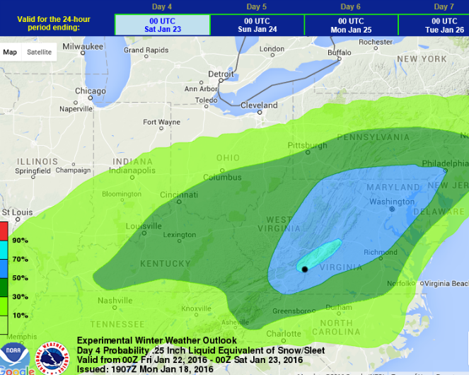
Weather Prediction Center / NOAA
Federal forecasters in Washington, D.C., are depicting unusually high levels of confidence for the potential of significant snow 4 days out. Roanoke (dot) actually barely fits within a 70-90% zone for at least 2.5 inches on Friday, with a broad area of 50-70%. Amounts will likely far exceed 2.5 inches, but that high of a percentage likelihood for even that much for a storm 4 days out is unusual.
Posted: Monday, January 18, 2016 10:30 pm
By Kevin Myatt | The Roanoke Times
There are many eye-popping numbers floating around for potential snowfall come Friday, but for now, I'm just going to settle on the word "several" to describe the number of inches that will probably fall in Southwest Virginia.
Before I dive into the complexities of the late-week winter storm, it should be noted that we will start out Tuesday with our coldest weather of the winter so far, with many lows in the single digits in outlying areas and at least the 10-15 range even into the Roanoke Valley. Also of note: An Alberta clipper storm system approaching from the west might bring some snow into Southwest Virginia, especially west of Roanoke, Wednesday afternoon and early evening. I would not rule out some minor accumulations quickly covering roadways in some spots -- the surface is much colder than it was for Sunday's brush of light snow. Something we should be aware of and not lose sight of in the rush to the big storm.
We are still about 72 hours from the start of the "big storm", so, yes, there are many things that can change. At this stage I think it is highly unlikely -- less than 5 percent chance -- that this storm somehow finds a way to simply miss us entirely in any direction. Also, it appears the cold high pressure systems to the north will be too strong for it take a northern track into Ohio and Pennsylvania, which seemed possible on some forecast models a few days ago. The northern track would have led to a few hours of mixed wintry precipitation changing to rain, perhaps the lowest impact setup other than a complete miss.
....
Nailing an inch count really isn't all that important right now. The important thing to know is that an overwhelming majority of the ways the late week system plays out in the atmosphere lead to amounts of snow that will restrict and potentially paralyze travel in our region this weekend.
Be prepared. Get prepared if you aren't already. If it ends up on the low end of present expectations, or even a little lower, save that preparation. Winter isn't over.
Contact Kevin Myatt at [email protected]. Follow him on Twitter @kevinmyattwx.
Posted in Weather Journal, Kevin Myatt on Monday, January 18, 2016 10:30 pm.
 = new reply since forum marked as read
Highlight:
NoneDon't highlight anything
5 newestHighlight 5 most recent replies
= new reply since forum marked as read
Highlight:
NoneDon't highlight anything
5 newestHighlight 5 most recent replies

MADem
(135,425 posts)I remember a storm in DC back in the mid-nineties that paralyzed the joint, where every idiot with an SUV was driving into phone poles, bridge abutments and ditches, because they thought "I have four wheel drive" meant "I can drive like I always do on slick, untreated and barely plowed roads!!!"
It totally sucked for the people on duty--there was no way to relieve them, so they were stuck, having to do double and triple duty until replacements were able to make their way into the city.
I had a shitty old front wheel drive Ford, and I drove, slowly and carefully, respectful of conditions, like someone who learned to drive in New England might do, past a number of these wet hens on their cellphones to the AAA!
I enjoyed that little mini-break! I went to the supermart for snacks, and the "video store" (how quaint a notion) for some movies to while away the day!! It was a lotta snow, IIRC. Nothing like last year up my way, but for DC, it was a lotta snow...!

mahatmakanejeeves
(57,605 posts)I'd better get to Total Wine and pick up a 30-pack of Genesee Cream Ale.
Forecasts converging on severe, potentially historic Friday-Saturday snowstorm
By Jason Samenow and Wes Junker January 19 at 11:10 AM
@capitalweather
A high-impact snowstorm for the region is nearing inevitability and there is some chance it will be historic, paralyzing travel and disrupting normal routines.
Every major computer model is now forecasting double-digit snowfall totals for the D.C. area Friday and Saturday.

GFS forecast model simulation at 7 p.m. Friday night. (WeatherBell.com)
The agreement among forecast models for a severe winter storm in this case is remarkable and a hallmark of some of our most memorable snow events. However, this storm is still three days from starting, which means there is time for shifts.
{The key characteristics of Washington, D.C’s biggest snowstorms}
The National Weather Service has raised its winter-storm-threat scale to its highest level. It warns there is potential for significant travel delays, closures, and threats to life and property, and is urging residents to start planning ahead.

The storm-threat assessment from the National Weather Service for Friday and Friday night. It is the same for Saturday, though not shown.
mahatmakanejeeves
(57,605 posts)My bolding key is wearing out.
Winter storm watch for Fri-Sat big snow; winter weather advisory for some snow today
Posted: Tuesday, January 19, 2016 9:45 pm | Updated: 11:03 am, Wed Jan 20, 2016.
By Kevin Myatt | The Roanoke Times
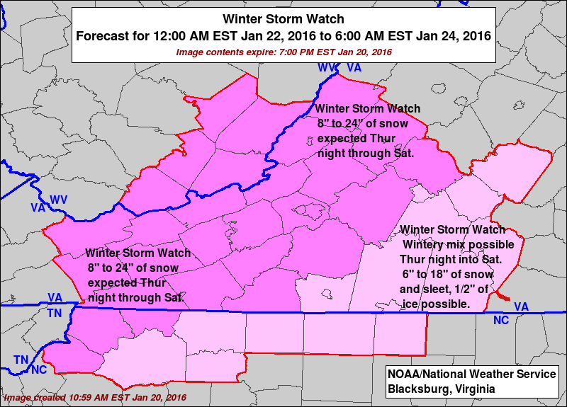
UPDATE 11 AM, 1/20: A winter weather advisory has been issued by the National Weather Service for the potential of up to 1 inch of snow this afternoon with an Alberta clipper system moving in from Kentucky and Tennessee ... a winter storm watch has been issued for Thursday night into Saturday for the potential of 8-24 inches of snow across the region. It is looking more and more likely that 1-2 feet of snow, locally more, will fall over most of the region -- possibly less west of I-77 and very near the North Carolina line -- from the upcoming major winter storm. BUT ... don't look past today's potential for snow-covered roads with a quick-hitting snow. END UPDATE
mahatmakanejeeves
(57,605 posts)By Perry Stein January 19 at 12:10 PM
@perrystein
....
Here’s what to do if you are in need of shelter, or see someone in need of a warm place to stay.
D.C.
Call the emergency DC Shelter Hotline at (800) 535-7252 or 311 if you or someone else needs shelter. Officials from the United Planning Organization will provide transportation to the appropriate shelter.
Two warming centers will also be open:
•Sherwood Recreation Center: 640 10th St. NE (women only)
•Emery Recreation Center: 5801 Georgia Ave. NW (co-ed)
For a full list of shelter sites click here.
Maryland
In Prince George’s County, the shelter hotline number is 1-888-731-0999. A list of warming centers open in the county can be found here.
In Montgomery County, the county crisis hotline number is 240-777-4000.
Virginia
Arlington County’s emergency winter shelter is open overnight and can be reached at 703-228-7395. It’s located at 2020-A 14th St. N.
Fairfax has a number of emergency shelters throughout the county. If you or someone is in need, call the county’s non-emergency number at 703-691-2131. A full list of shelters can be found here.
Alexandria’s winter hypothermia emergency shelter can be reached at 703-548-7500, ext. 231. For additional shelter services, call 703-746-5700.