Welcome to DU!
The truly grassroots left-of-center political community where regular people, not algorithms, drive the discussions and set the standards.
Join the community:
Create a free account
Support DU (and get rid of ads!):
Become a Star Member
Latest Breaking News
General Discussion
The DU Lounge
All Forums
Issue Forums
Culture Forums
Alliance Forums
Region Forums
Support Forums
Help & Search
Virginia
Related: About this forum@NWS_BaltWash has issued a tornado watch for the region.
.@NWS_BaltWash has issued a tornado watch for the region.
http://dcist.com/2018/09/tornado_watch.php …
Link to tweet
A tornado watch has been issued for parts of District of Columbia, Maryland and Virginia until 10 PM EDT
Link to tweet
Tornado WATCH issued for D.C. region as storms move north into the area. This means tornadoes are possible and we need to "watch" for further development. If a warning is issued, take shelter. https://wapo.st/2MGFYqK
Link to tweet
InfoView thread info, including edit history
TrashPut this thread in your Trash Can (My DU » Trash Can)
BookmarkAdd this thread to your Bookmarks (My DU » Bookmarks)
4 replies, 870 views
ShareGet links to this post and/or share on social media
AlertAlert this post for a rule violation
PowersThere are no powers you can use on this post
EditCannot edit other people's posts
ReplyReply to this post
EditCannot edit other people's posts
Rec (1)
ReplyReply to this post
4 replies
 = new reply since forum marked as read
Highlight:
NoneDon't highlight anything
5 newestHighlight 5 most recent replies
= new reply since forum marked as read
Highlight:
NoneDon't highlight anything
5 newestHighlight 5 most recent replies
= new reply since forum marked as read
Highlight:
NoneDon't highlight anything
5 newestHighlight 5 most recent replies
@NWS_BaltWash has issued a tornado watch for the region. (Original Post)
mahatmakanejeeves
Sep 2018
OP

Yonnie3
(17,420 posts)1. Tornado Warning
Edit: Link on https://www.weather.gov/lwx/ NWS Forecast Office Baltimore/Washington
https://forecast.weather.gov/wwamap/wwatxtget.php?cwa=lwx&wwa=tornado%20warning
Tornado Warning
VAC041-075-085-087-145-760-172115-
/O.NEW.KAKQ.TO.W.0036.180917T2044Z-180917T2115Z/
BULLETIN - EAS ACTIVATION REQUESTED
Tornado Warning
National Weather Service Wakefield VA
444 PM EDT MON SEP 17 2018
The National Weather Service in Wakefield has issued a
* Tornado Warning for...
The City of Richmond in central Virginia...
North central Chesterfield County in central Virginia...
Southeastern Goochland County in central Virginia...
Northwestern Henrico County in central Virginia...
Central Hanover County in central Virginia...
East central Powhatan County in central Virginia...
* Until 515 PM EDT.
* At 443 PM EDT, a severe thunderstorm capable of producing a tornado
was located near Manakin, or near Bon Air, moving northeast at 35
mph.
HAZARD...Tornado.
SOURCE...Radar indicated rotation.
IMPACT...Flying debris will be dangerous to those caught without
shelter. Mobile homes will be damaged or destroyed.
Damage to roofs, windows, and vehicles will occur. Tree
damage is likely.
* This dangerous storm will be near...
Bon Air, University Of Richmond and Tuckahoe around 455 PM EDT.
Wyndham around 500 PM EDT.
Richmond, Laurel and Lakeside around 505 PM EDT.
Mechanicsville, Glen Allen and East Highland Park around 510 PM
EDT.
Ashland, Randolph Macon College, Hanover and Studley around 515 PM
EDT.
Other locations impacted by this tornadic thunderstorm include
Hanover Airport, Gum Tree, Midlothian, Elmont, Short Pump, Longdale,
Solomons Store, Chamberlayne, Atlee and Ashcake.
PRECAUTIONARY/PREPAREDNESS ACTIONS...
TAKE COVER NOW! Move to a basement or an interior room on the lowest
floor of a sturdy building. Avoid windows. If you are outdoors, in a
mobile home, or in a vehicle, move to the closest substantial shelter
and protect yourself from flying debris.
Please report severe weather by calling 757-899-2415, posting to the
NWS Wakefield Facebook page, or using Twitter @NWSWAKEFIELDVA.
&&
LAT...LON 3787 7745 3782 7741 3781 7742 3780 7739
3778 7740 3780 7736 3779 7733 3776 7734
3775 7730 3773 7732 3774 7729 3771 7729
3772 7727 3772 7725 3773 7725 3773 7724
3769 7724 3769 7720 3747 7768 3756 7777
TIME...MOT...LOC 2043Z 228DEG 31KT 3753 7767
TORNADO...RADAR INDICATED
HAIL...<.75IN
$$
SCALORA

mahatmakanejeeves
(57,290 posts)2. I'm going to need an umbrella. It's raining in downtown DC now.
I brought one with me to work, so no biggie.
Hope all is well in C'ville.
Yonnie3
(17,420 posts)3. High water in Waynesboro
It got within a few inches of the lower warehouse floor where the lighting gear is stored. River gauges show that the peak has been reached and it is going down.
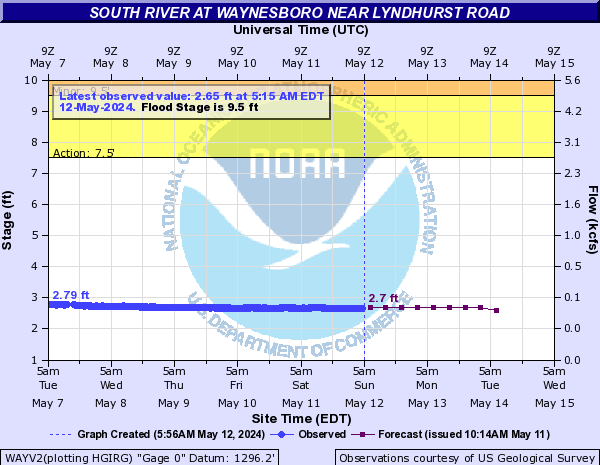
This is a link to NOAA's Hydrologic Predictions so it the graph is not a static jpeg.
Yonnie3
(17,420 posts)4. Reports of one death and injuries near Richmond.
Heard on radio that tornado in Midlothian killed one. Will get link when I can. Mobile right now.