Welcome to DU!
The truly grassroots left-of-center political community where regular people, not algorithms, drive the discussions and set the standards.
Join the community:
Create a free account
Support DU (and get rid of ads!):
Become a Star Member
Latest Breaking News
General Discussion
The DU Lounge
All Forums
Issue Forums
Culture Forums
Alliance Forums
Region Forums
Support Forums
Help & Search
California
Related: About this forumA [map] collection that identifies California as a world apart (LA Times)
A really nice article on a map collection all showing CA as an island, just donated to Stanford. I hope these go on public display (along with some of the Rumsey material) - would be worth a visit for sure...
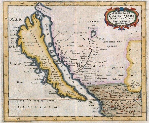
PALO ALTO — Something was unusual about the 1663 map of the Western Hemisphere.
Yes, much of the North and South American coasts followed contours geographers would recognize today. And in California, Santa Catalina, Santa Barbara and Point Reyes were clearly marked. But wait! What was that body of water marked Mare Vermiglio, or Red Sea, separating California from the mainland? And why was California a big carrot-shaped island?
That geographic oddity caught the attention of Glen McLaughlin, an American businessman who was browsing through antique maps at a shop in London in 1971. He bought it — and began pursuing a quirky and expensive passion that would lead him to devote an entire room in his San Jose-area home to what is believed to be the largest private collection of such maps.
-- Snip --
"California is not an island and doesn't have an east coast and no Vermilion Sea. But it is so separate from other parts of the United States, economically, culturally and even spatially," Solnit said. With mountains and deserts isolating California, and its agriculture, high-tech and entertainment industries so well developed, "who's to say we are not this magical, amazing place?"
http://www.latimes.com/news/local/la-me-island-maps-20121217,0,6950188.story
InfoView thread info, including edit history
TrashPut this thread in your Trash Can (My DU » Trash Can)
BookmarkAdd this thread to your Bookmarks (My DU » Bookmarks)
2 replies, 1747 views
ShareGet links to this post and/or share on social media
AlertAlert this post for a rule violation
PowersThere are no powers you can use on this post
EditCannot edit other people's posts
ReplyReply to this post
EditCannot edit other people's posts
Rec (4)
ReplyReply to this post
2 replies
 = new reply since forum marked as read
Highlight:
NoneDon't highlight anything
5 newestHighlight 5 most recent replies
= new reply since forum marked as read
Highlight:
NoneDon't highlight anything
5 newestHighlight 5 most recent replies
= new reply since forum marked as read
Highlight:
NoneDon't highlight anything
5 newestHighlight 5 most recent replies
A [map] collection that identifies California as a world apart (LA Times) (Original Post)
petronius
Dec 2012
OP

pinto
(106,886 posts)1. Interesting stuff. The perception of CA as an island may come from the annual flooding
of the San Joaquin Valley during the rainy season. Apparently it filled with rain water and was essentially a large, north-south fresh water lake for months every year. Before large scale farming or diversion of water to the coastal cities.

nadinbrzezinski
(154,021 posts)2. From the seal, that was commisioned by the colonial
Government in Guadalajara, not Mexico City, fascinating.