Quebec orders more evacuations as dozens of wildfires in Canada remain out of control
Source: AP
2 hours ago
MONTREAL (AP) — Northern Quebec’s largest town was being evacuated on Tuesday as firefighters worked to beat back threats from out-of-control blazes in remote communities in the northern and northwestern parts of the province.
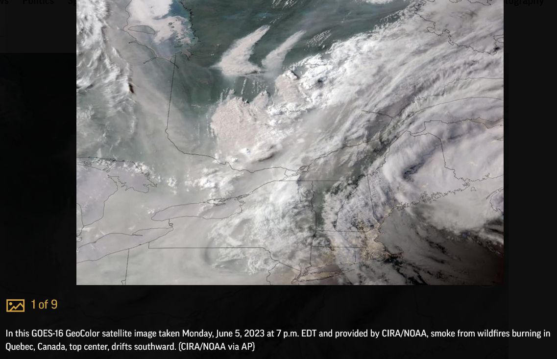
According to the province’s forest fire prevention agency, more than 150 forest fires were burning in the province on Tuesday, including more than 110 deemed out of control. The intense Canadian wildfires are blanketing the northeastern U.S. and parts of Eastern Canada in a haze, turning the air acrid, the sky yellowish gray and prompting warnings for vulnerable populations to stay inside.
The effects of hundreds of wildfires burning in Quebec could be felt as far away as New York City and New England, blotting out skylines and irritating throats.
Late Tuesday, authorities issued an evacuation order for Chibougamau, Quebec, a town of about 7,500 in the remote region of the province. Authorities said the evacuation was underway and promised more details Wednesday.
Read more: https://apnews.com/article/wildfires-canada-quebec-3291016eaa4905177c90feae02a139c5
 = new reply since forum marked as read
Highlight:
NoneDon't highlight anything
5 newestHighlight 5 most recent replies
= new reply since forum marked as read
Highlight:
NoneDon't highlight anything
5 newestHighlight 5 most recent replies
Novara
(5,838 posts)... in Michigan. I've never seen that before. Right where I am I can see four overlapping smoke plumes on the EPA's AirNow site. Most of the east coast is affected by smoke plumes. Smoke covers the US from Kansas to the east coast.

BumRushDaShow
(128,732 posts)when the NWS and local TV mets here in Philly mentioned those. I last left off with Nova Scotia smoke drifting down here to mix with the NJ smoke and before that, the Alberta smoke.
The traffic reports earlier this morning were indicating the visibility had dropped to under 2 miles or less in some spots.
The Omega Block's low over New England has been pumping the smoke down along its counter-clockwise rotation.
(from GOES-EAST about 15 minutes ago)


ancianita
(36,014 posts)BumRushDaShow
(128,732 posts)


sybylla
(8,505 posts)It is so rare that we get weather from the east. The only break we've gotten is when it's shifted to coming out of north - an even more rare event that has happened frequently the past four weeks. And very little rain.
Before that all we had was snow/rain for 6 weeks almost straight. We had climbed out of our drought status in March only to be thrown back into it 12 weeks later.
Even in an El Nino, this means #ClimateChanged.
BumRushDaShow
(128,732 posts)(either an Omega Block like now or a Rex Block, that is more common earlier in the year) then you can sometimes get those easterlies blowing in.

Right now it looks something like this -

I think the blocking is supposed to start to break down soon and transition into more of a zonal flow, although that is still keeping things dry. Need some tropical storm remnants to send some moisture up here out of the GOM!
sybylla
(8,505 posts)I always have my eye on the weather and have lived here all my life. This kind of weather pattern might happen for a week, not 4-6 weeks.
Most of the lower half of Wisconsin has had less than a half inch of rain since May 1. I planted my garden on Sunday and didn't bother watering it. The soil was dust and hot (as in uncomfortable on my fingers) down to 3" even with Canadian wildfire haze for a week strait. Watering it won't pay until we get rain.
For 4 years we have had westerlies and strong winds nearly all the freaking time. Since Mid May it's been still. I welcome this because I hate strong wind. Having it constantly was also usual in the part of the state where I grew up.
But, you know, this is just anecdotal, so it's all bs, right?
BumRushDaShow
(128,732 posts)The patterns would usually flip after about 6 weeks and agree, this past year, there was an extended pattern where here in Philly, we basically had no winter (I had 1.20" of "frozen" precip. between Nov. - Mar. and the official reading at KPHL was less than an inch - normal is around 21" ). Everything was basically suppressed to our south and what we did end up getting from coastal nor'easters ended up too warm to produce snow from Philly on east across Jersey to the Atlantic because they were coast huggers (meaning we got mostly cold rain with some sleet or wet flakes mixed in). Further inland got it though.
The month of May, I had 0.32" of rain and KPHL recorded 0.24", which made it the driest May on record. The only thing that half held around me was that literally the last 5 days of April, I got a total of about 5" of rain. Then in May, the spigot was shut off.
Where you are is in or at least adjacent to "The Northern Plains®" where the winds reside. 
In one respect, thanks to this weird pattern, I am happy for the west and southwest because they were able to take a significant chunk out of their long-term drought - mainly due to the odd 3-peat La Nina. Will have to see what the upcoming El Nino does considering that the ocean SSTs are running warmer than usual already.

Bayard
(22,038 posts)All having respiratory distress. He sent me pics of beautiful hills and forests, all overlaid with a blanket of smoke.

cbabe
(3,538 posts)Ontario seeing more forest fires amid unprecedented season across ...
1 day agoOntario has seen active forest fires increase, particularly in the province's northeast. As Shallima Maharaj reports, officials are on high alert. Relentless wildfires have devoured 3.3 million...
(Canada was promoted as the climate warming escape hatch for the US. Go north for safety. Once upon a time.)
IbogaProject
(2,800 posts)The water from the limited snow melt didn't wet the soil beyond 12 inches down. The weird winds from the east are part of the breakdown in the Jet Stream where the band that usually keeps arctic air up in the arctic is much more wobbly, and we can get a long batch of either unseasonably warm or cool air. Both are early stages of a climate collapse. The whole thing will pay out over 12-18 years, so buckle up everything we have known will be gone soon. https://arctic-news.blogspot.com/