Terrifying images show fiery column looming over Caldor Fire near Lake Tahoe
Source: sfgate
Katie Dowd Updated: Aug. 17, 2021 6:08 p.m.
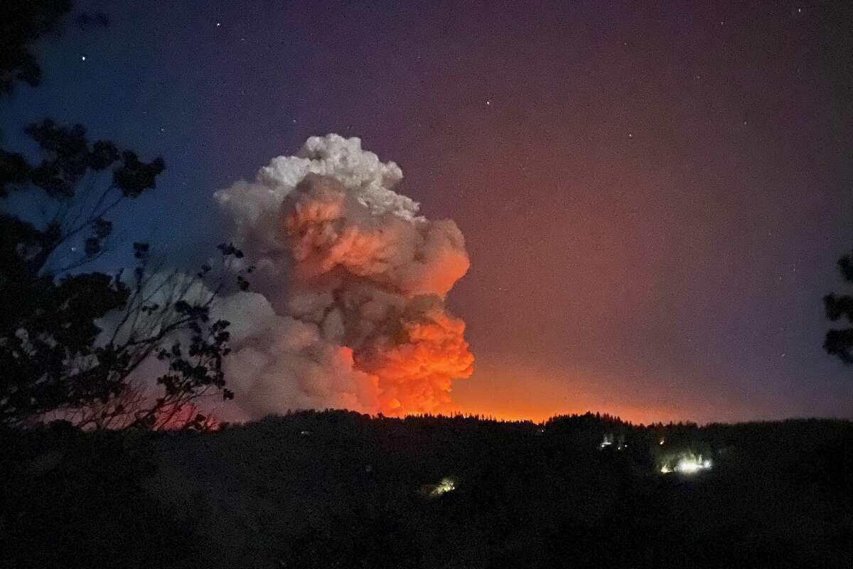
Wildfire cameras captured terrifying images Monday afternoon of the massive column of smoke and flames rising up from the Caldor Fire burning near Lake Tahoe.
The wildfire camera positioned on Leek Spring Hill, about 40 miles southwest of South Lake Tahoe, showed the blaze looking more like an erupting volcano than the type of wildfires that Californians are sadly accustomed to.
"Radar shows the smoke plume at about 20,000 feet," said Cory Mueller, a meteorologist with the National Weather Service's Sacramento office. "For a fire, that’s pretty good."
"It's very scary," said Neil Lareau, a professor of atmospheric sciences in the department of physics at the University of Nevada at Reno who studies wildfire-generated weather. "We have the worst mix of things you could put together for fires, which is a combination of dry vegetation, strong, shifting winds and an atmosphere conducive to these deep smoke plumes."......................
Read more: https://www.sfgate.com/california-wildfires/article/caldor-fire-tahoe-smoke-california-fires-16393428.php?utm_campaign=CMS%20Sharing%20Tools%20(Premium)&utm_source=t.co&utm_medium=referral
I was hiking around Lake emerald and Tahoe area about 5 years ago. So magnificent--and peaceful.
This is beyond terrifying to see.
-Updates: Get info on the Caldor Fire from the El Dorado National Forest.
-Information line: (530) 303-2455
-Maps: Find from the U.S. Forest Service.
“Terrifying images show fiery column looming over Caldor Fire near Lake Tahoe” Oh, hell…
Link to tweet
?s=20
Guy Tucker photographed the Caldor Fire 3 miles due west from Fair Play, Calif., late Monday night on Aug. 16, 2021.
 = new reply since forum marked as read
Highlight:
NoneDon't highlight anything
5 newestHighlight 5 most recent replies
= new reply since forum marked as read
Highlight:
NoneDon't highlight anything
5 newestHighlight 5 most recent replies

AllaN01Bear
(22,494 posts)2 dry years of drought and trees infested with bark beetles and weekened from other drought . its a tinder box. eep.

Mr.Bill
(24,612 posts)in California is owned by the Federal Government. Why did Trump let their forests get in this condition?

Grokenstein
(5,792 posts)A monstrously stupid bastard and a monstrously stupid administration.

multigraincracker
(33,637 posts)of carbon in the atmosphere.

hatrack
(60,372 posts)Nice planet we had there. Shame we let something bad happen to it.

burrowowl
(17,921 posts)

riversedge
(72,114 posts)California Wildfires
Traffic nightmare unfolds as Caldor Fire near Tahoe triggers more evacuations
https://www.sfgate.com/california-wildfires/article/Wildfire-near-Lake-Tahoe-triggers-more-evacuations-16392127.php
Photo of Amy Graff
Amy Graff
, SFGATE
Aug. 17, 2021
Updated: Aug. 17, 2021 7:49 p.m.
UPDATE Aug. 17, 7:46 p.m. More mandatory evacuations have been ordered Tuesday evening for the following areas:....................................

calimary
(83,517 posts)Looks like a guy with glasses and a right-side part in his hair. Roy Orbison ones to mind.
Laura PourMeADrink
(42,770 posts)riversedge
(72,114 posts)riversedge
(72,114 posts)riversedge
(72,114 posts)Nature is beautiful --
I know it is dangerous but have to say, this pic is really spectacular.
The pyrocumulonimbus clouds being produced by the #DixieFire are producing frequent lightning, including several cloud-to-ground lightning strikes in the last 20 minutes, which could potentially spark new fires. #CAwx #CAfire
Link to tweet
?s=20
riversedge
(72,114 posts)@NWSSacramento
·
1h
Satellite Here is the latest satellite data showing the growth of the #DixieFire, #McFarlandFire, and the #CaldorFire from this morning's #MODIS pass over #NorCal. With critical fire weather in the forecast, please continue to practice fire weather safety. #CAwx #CAfire
Link to tweet
?s=20
riversedge
(72,114 posts)Warning sign Updated version of the Red Flag Warning graphic. Red Flag Warning is in effect through 8pm Wednesday due to gusty winds & extremely dry conditions.
Link to tweet
?s=20
Mr.Bill
(24,612 posts)Summer.

pfitz59
(10,749 posts)Both being threatened by fire. The trillion$ spent on Afghanistan and the shit-gibbon's wall could have been spent on fuels reduction (AKA "raking the forest" ) Politicians are too busy pissing on each other to care.