General Discussion
Related: Editorials & Other Articles, Issue Forums, Alliance Forums, Region ForumsArctic Sea Ice Gone By September 2019?
This guy thinks so. I am very skeptical but will keep an eye on it for sure.
http://arctic-news.blogspot.com/2019/07/arctic-sea-ice-gone-by-september-2019.html
The Most Important Event On The Planet Right Now
https://www.patreon.com/posts/28765160?fbclid=IwAR2RcppeueC5V1LhLzJE3WMZcqwvfymwTZuCt5xpW8DEq5HWjLPssOlIbfY
 = new reply since forum marked as read
Highlight:
NoneDon't highlight anything
5 newestHighlight 5 most recent replies
= new reply since forum marked as read
Highlight:
NoneDon't highlight anything
5 newestHighlight 5 most recent replies

JoeOtterbein
(7,699 posts)
SamKnause
(13,088 posts)He explains in horrifying detail what happens after.
There is no technology on a world scale that can stop what is coming.
If the technology were invented tomorrow, it is too late to stop what is coming.
Climate change is happening faster then scientist originally thought, or would admit to the public.
Much faster.

Quixote1818
(28,920 posts)when that happens it causes the snow to melt at unprecedented rates.

misanthrope
(7,411 posts)They likely only went with conservative estimates to err on the side of caution and responsibility. There were still a lot of unknowns regarding feedback loops.

maryellen99
(3,785 posts)hatrack
(59,578 posts)Not permanently - a seasonal ice-free Arctic.
maryellen99
(3,785 posts)hatrack
(59,578 posts)Think this spring in the Midwest, but much worse - more extreme floods, longer cold snaps, longer droughts and weather patterns getting stuck in place and driving events like these.
What powers the jet stream (and really world weather) is the temperature difference between the equator and the poles. The greater the difference in temperature, the greater the speed and force (and relative flatness) of the jet stream. When that temperature difference falls rapidly, like it's doing now, the jet stream wavers and wobbles and slows down. It stretches N-S in long loops, rather than moving in a relatively flat wave.
That means more moisture gets transported farther north to melt even more of the Arctic, with a fair amount of that moisture falling out on the way. It also means that fronts pass more slowly, since the jet stream is already moving up and down much more than it used to in the Northern Hemisphere.
This is all kind of an oversimplification, because it's a complex process, but we're seeing events like these now, with about 80% of the Arctic ice by volume already gone compared to the 1979 satellite data baseline. These videos provide additional information.

muriel_volestrangler
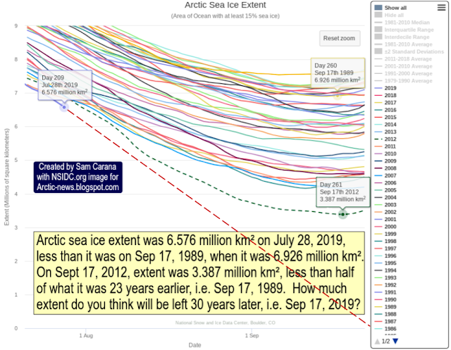
(101,271 posts)As the graph shows, that has never happened before. Not surprising, because the sun is moving away from the Arctic.
The latest actual predictions, from groups that know what they're talking about, made between 3rd and 12th July, are here:
The projected median Arctic September extent from all contributions is 4.28 million square kilometers, with a quartile range of 4.0 to 4.6 million square kilometers. This is a slight drop from the June median Outlook of 4.4 million square kilometers, which is not surprising given the relatively rapid decline in ice extent during June. The change from June to July was almost exclusively due to a drop in the extent of the statistical contributions; the median of model and heuristic contributions changed very little. One contribution projects a new record low extent of 3.06 million square kilometers, while the highest projection is nearly six million square kilometers. The model contributions projected higher extent, on average, than the statistical and heuristic methods, which was also the case for June 2019 submissions and throughout the 2018 season. The range in the model projections is also larger than the other two methods
https://www.arcus.org/sipn/sea-ice-outlook/2019/july
6 million sq km is bound to be too high; we've already dropped from about 8.7 when the predictions were being made to 6.3. The record low in 2012 came after a particularly warm August, so it would need another of those to break that record - possible, but by no means certain. If the August/early Sept drop is similar to recent years, it will probably be a minimum of 4 million sq km or just under - 2nd lowest ever.
hatrack
(59,578 posts)And in terms of practical impacts, a BOE wouldn't have to be 100% ice-free everywhere in the basin to really fuck up the jet stream, with all that entails.
Meanwhile:
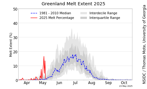
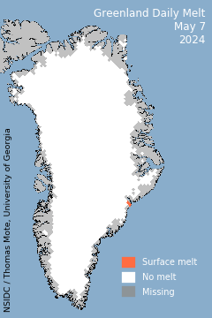
https://nsidc.org/greenland-today/
