Volume 63 Number 4, July/August 2010 by Arlen F. Chase, Diane Z. Chase, and John F. Weishampel
Even when one is almost directly on top of them, many Maya sites are impossible to see. In the jungle, small palms and brush can spring to 14 feet high in a year, filling the space between towering cedar, mahogany, ramon, and ceiba trees. When we can find large Maya sites, we cannot easily map them because it is expensive and labor-intensive. Even modern electronic distance meters have limited functionality; if we can't see through the trees, neither can they. So we cut paths with machetes, scramble through thick underbrush, and wonder what we might be missing. The ability to see through this dense, steamy jungle has long been the dream of Maya archaeologists.
These difficulties have led us to underestimate the accomplishments and ingenuity of the ancient Maya. There is little agreement among archaeologists over just how big some Maya cities were, how many people lived in them, or how intensively their residents modified the landscape. It often appears that sites in more easily studied areas of the worldplains, sparse forests, or areas cleared in modern timesare larger and more complex than their tropical forest counterparts. Does this impression reflect the inability of ancient humans to create large, sustainable settlements in the tropics, or is it the result of incomplete investigations, hampered by the complications of working in a rainforest?
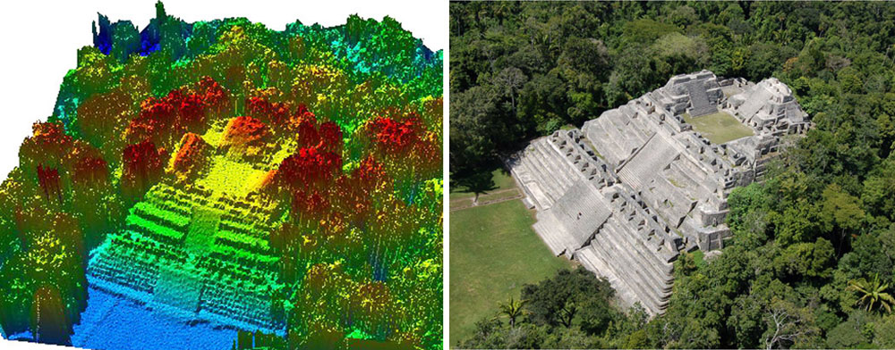
For more than 25 years, wea multidisciplinary team from the University of Central Floridahave struggled to document the jungle-covered archaeological remains at Caracol in western Belize. Caracol was occupied from 600 B.C. to A.D. 900 by a population that we believe peaked with at least 115,000 inhabitants. A system of radial roads, or causeways, links different parts of the site across most of Belize's lush Vaca Plateau. We have mapped, using traditional on-the-ground techniques, approximately 9 square miles of settlement, 1.3 square miles of terracing, and 25 miles of causeways. We have also studied the buildings and pyramids of the site's center, as well as 118 residential groups that consist of rubble foundations and stone buildings arranged around a central plaza. Our work so far clearly establishes Caracol as the largest known archaeological site in the southern Maya lowlands, but reconnaissance and scouting suggest that the city was even larger than was previously thought. Despite the quantity of data we have, there are still lingering questions about the site's true size and population, and about the density of the terrace systems that the ancient Maya constructed for agriculture. To answer these difficult questions without spending another 25 years in the field, we clearly needed a new strategya way to "see" through the dense forest covering the archaeological remains.
For the last three decades archaeologists all over the world have been using space-based imaging tools to better understand ancient landscape and settlement patterns. Like their colleagues, Maya archaeologists have turned to these techniques to overcome the complications of working beneath a forest canopybut often with little success. Generally, we have only been able to see archaeological features that extend above the canopy, are in areas devoid of vegetation, or disrupt the forest in a bold way. Even large pyramids can escape the eye in the sky. A newer remote-sensing technology called LiDAR (Light Detection and Ranging), operated from a plane rather than a satellite, has helped us penetrate the jungle of Caracol and promises to revolutionize our understanding of Maya civilization. (Laser-based on-the-ground scanning, featured in "The Past in High-Def," May/June 2009, is also gaining traction in the archaeological world.)
more
http://www.archaeology.org/1007/etc/caracol.html